Tree Geometry
At a Glance
| Challenge | Responding to tree-by-tree variations in canopy geometry when performing canopy-focussed tasks such as spraying, spreading and pruning. |
|---|---|
| Solution | Green Atlas Cartographer directly measures tree geometry (height, density, area/volume and leaf-area) using its integrated LiDAR. |
| Result | A fast and accurate method for directly measuring tree canopy geometry, with multiple measurements of every tree. Enables relative biomass estimation, vigour assessment, light interception estimation, and precise tree-row-volume calculation. |
| Applicable Crops | All crops and stages. |
| Enables | Variable rate spraying and spreading, precision pruning (canopy and roots), tree-row-volume calculation and biomass/carbon estimation. |
Tree Structure Variability is Hard to See
Treating orchards as flat surfaces ignores critical 3D variability.
Orchard management often treats a block as a uniform 2D surface, ignoring the variability between individual trees:
- Chemical Waste: Sprayers calibrated for the largest trees over-spray smaller, younger trees, causing chemical runoff.
- Subjective Vigour Assessment: Agronomists rely on visual eye-balling to identify vigour zones, which is prone to error and cannot be quantified for year-over-year comparison.
- Manual Measurement Limitations: Physically measuring tree height, canopy width, or leaf area index for thousands of trees is practically impossible.
LiDAR Powered Structural Measurement
Centimetre-level precision at orchard speed.
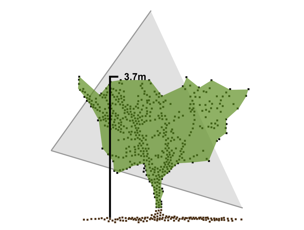
Green Atlas Cartographer uses industrial-grade LiDAR to shoot laser beams at and through the tree canopy hundreds of thousands of times per second, creating a high-density point cloud while driving past at speeds greater than 20km/h.
- Direct 3D Measurement: Unlike camera-only systems that infer tree geometry from surface images, Cartographer's LiDAR directly measures height, width, volume and density with centimetre-level precision.
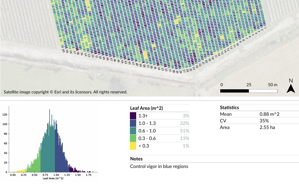
- Canopy Density and Leaf Area: By analysing how laser pulses penetrate the foliage, the system calculates canopy density and leaf area, providing far more accurate metrics than visual greenness or remote sensing such as NDVI.
- Automated Spatial Mapping: Millions of data points are automatically aggregated into per-tree, per-row and per-block summaries, accessible as high-resolution geo-registered heatmaps or digital prescription files.
Precision Orchard Management
Direct measurement enables a suite of high-value, automation-ready applications
- Tree-Row-Volume (TRV) Calculation: Calculate the exact volume of foliage to determine precise water or chemical requirements, significantly reducing spray-to-ground waste.
- Light Interception Estimation: With significant research linking light intensity throughout a canopy to fruit growth, precise geometry data helps growers manage what matters most.
- Targeted Vigour Management: Identify hot spots of excessive growth requiring aggressive pruning or reduced nitrogen, or weak zones needing soil amendments or drainage checks.
- Pest and Disease Pressure: Canopy weak spots often indicate pest or disease outbreaks. Early identification allows precise targeting for remediation.
- Quantified Biomass and Carbon: Directly measure physical wood and leaf mass, providing a data-backed foundation for carbon sequestration estimation and biomass monitoring.
Applications Enabled by Tree Geometry Data
The foundation for advanced orchard activities.
Variable Rate Spraying and Spreading
Use the tree geometry map to create prescription files for smart sprayers or spreaders that automatically adjust flow-rate based on the volumetric properties of each tree. Reduces chemical costs and environmental footprint while improving orchard uniformity.
Precision Pruning
Use vigour maps to direct crewed or automated mechanical pruning to target high-biomass areas. Results in balanced tree architecture, improved light interception, and more consistent fruit quality.
Light Interception Estimation
Estimate sunlight penetration based on 3D geometry. Enables data-driven decisions on canopy pruning and thinning to optimise light-to-leaf-to-fruit ratios for the highest fruit quality.
Precision Root Management
Correlate high or low-vigour canopy zones with soil data to perform targeted root pruning or localised fertilisation, pushing the entire block toward a uniform production standard.
Get Started
Map the geometry of your orchard.
Find your nearest Green Atlas service provider to discuss how tree geometry data can improve your operations.