Task Maps
At a Glance
| Challenge | Optimising orchard equipment or labour use to minimise costs, and targeting manual labour precisely to address different needs across the orchard. |
|---|---|
| Solution | Green Atlas Cartographer rapidly provides accurate task maps, giving labour crews or equipment operators the precise actions required at each tree. |
| Result | A faster, lower-cost ability to turn data into in-field actions. Available resources are used in the most efficient way possible. |
| Applicable Crops | All Cartographer supported crops and stages. |
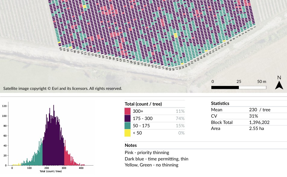
| Typical Usage | Thinning guidance, row-by-row summary for bin placement, and labour/time estimates. |
| Outputs | Georegistered PDF task maps, traffic-light maps, contour maps, or custom map types. |
Efficiently Managing Variability at Scale
Uniform management creates systemic inefficiency.
In any commercial orchard, a primary driver of cost is variability. When every tree is different, applying a uniform management strategy leads to:
- Subjective Decision Making: Labourers and operators rely on visual estimation, leading to inconsistent results and decision fatigue.
- Misallocated Resources: High-productivity areas are under-treated while low-productivity areas receive unnecessary inputs.
- Inaccurate Budgeting: Estimating time and labour for seasonal tasks is often an educated guess, leading to shortages or expensive overtime.
- Scouting Bottleneck: Manual ground-truthing is far too slow to cover an entire orchard. By the time counting is finished, the ideal intervention window may have closed.
From Big Data to Actionable Task Maps
Simple, colour-coded instructions for every tree.
Green Atlas Cartographer bridges the gap between raw spatial data and in-orchard execution.
- Total Orchard Visibility: Every single tree is scanned at high speed, providing an accurate census of fruit count, flower density, or canopy geometry.
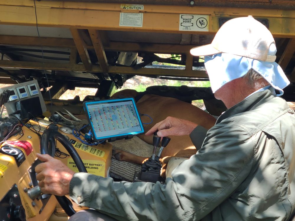
- Simplified Operator Interfaces: Complex data is distilled into colour-coded Action Zones. Maps can be loaded onto phones, tablets, tractor GPS systems (GeoJSON/Shapefiles), or handed to crews as printed reports.
- Optimised for Multiple Operations: Tree-level maps support thinning, pruning and spraying. Row-level aggregation enables forward-planning for bin placement, replanting, and logistics.
- Prescriptive Guidance: Operators receive precise, geo-located instructions for every metre of the row, allowing them to focus on execution rather than estimation.
Maximum ROI through Targeted Execution
Every hour and every litre utilised with maximum efficiency.
| Increased Work Rate | Crews move faster by skipping areas that require zero intervention, focusing purely on problem zones. |
|---|---|
| Input Savings | Targeted execution reduces labour, chemicals, water, and mechanical wear required to achieve desired outcomes. |
| Optimised Spend | When budget or timelines are fixed, task maps ensure the most efficient use of available resources. |
| Improved Crop Quality | Precise intervention leads to greater crop uniformity, improving pack-out rates and stabilising year-on-year yields. |
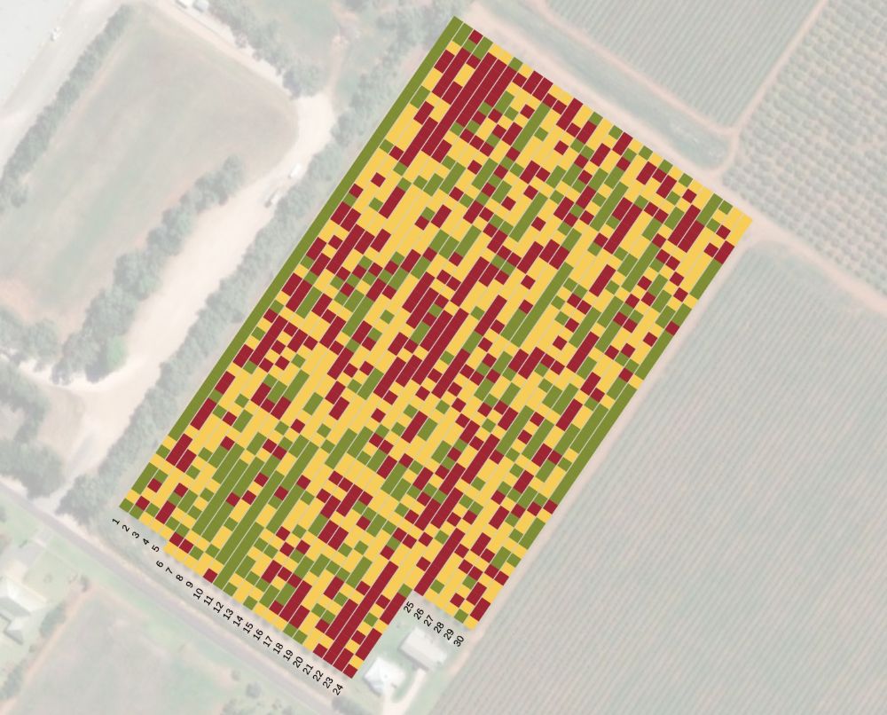
Example: Shaker Task Maps for Precision Thinning
Real-time guidance for prune/sugar-plum fruitlet thinning.
A mechanical shaker is used to knock off excess fruitlets to ensure remaining fruit grows to premium size. The operator sees a traffic-light colour-coded grid on their in-cabin display:
| Red — Long Shake | High fruitlet density. Requires aggressive thinning. |
|---|---|
| Orange — Short Shake | Moderate density. Trees only require a light touch. |
| Green — Skip | At or below ideal density. Drive straight past without stopping. |
This prevents over-thinning light crops and ensures heavy crops are thinned enough to reach optimum market-grade size, all while increasing hectares covered per shift.
Get Started
Put task maps to work in your orchard.
Find your nearest Green Atlas service provider to discuss how task maps can streamline your operations.